1. Convertir votre fichier d'adresses en un fichier CSV avec 4 colonnes :
- Adresse
- Code postal
- Ville
- Pays
2. Ouvrir QGIS
3. Installer le plugin MMQGIS
4. Une fois le plugin installé aller dans MMQGIS / Geocode / Geocode CSV with Google
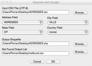
5. Choisir le fichier CSV en entrée, renseigner les champs à utiliser pour le geocodage et pour terminer, définir les fichiers de sorties
6. Patienter un peu et le fichier shape sera ajouté à QGIS une fois le géocodage terminé


12 juin 2014 — 13 h 06 min
Vraiment top ce blog :p
3 juillet 2014 — 9 h 23 min
Bonjour,
j'ai un soucis avec mmqgis, a chaque fois que je veux geocoder un fichier d'adresse .csv i lme retourne une erreur de type:
Une erreur est apparue lors de l'exécution du code python :
Traceback (most recent call last):
File "C:UsersTECH-REGIE/.qgis2/python/pluginsmmqgismmqgis_dialogs.py", line 1148, in run
shapefilename, notfoundfile, fields, service, 1)
File "C:UsersTECH-REGIE/.qgis2/python/pluginsmmqgismmqgis_library.py", line 1728, in mmqgis_geocode_web_service
attributes.append(unicode(row[z], 'utf-8').strip())
UnicodeDecodeError: 'utf8' codec can't decode byte 0x90 in position 14: invalid start byte
Version de Python :
2.7.5 (default, May 15 2013, 22:44:16) [MSC v.1500 64 bit (AMD64)]
Version de QGIS :
2.0.1-Dufour Dufour, d94c044
Chemin vers Python : ['C:/PROGRA~1/QGISDU~1/apps/qgis/./python/plugins\processing', 'C:/PROGRA~1/QGISDU~1/apps/qgis/./python', 'C:\Users\TECH-REGIE/.qgis2/python', 'C:\Users\TECH-REGIE/.qgis2/python/plugins', 'C:/PROGRA~1/QGISDU~1/apps/qgis/./python/plugins', 'C:\PROGRA~1\QGISDU~1\bin\python27.zip', 'C:\PROGRA~1\QGISDU~1\apps\Python27\DLLs', 'C:\PROGRA~1\QGISDU~1\apps\Python27\lib', 'C:\PROGRA~1\QGISDU~1\apps\Python27\lib\plat-win', 'C:\PROGRA~1\QGISDU~1\apps\Python27\lib\lib-tk', 'C:\PROGRA~1\QGISDU~1\bin', 'C:\PROGRA~1\QGISDU~1\apps\Python27', 'C:\PROGRA~1\QGISDU~1\apps\Python27\lib\site-packages', 'C:\PROGRA~1\QGISDU~1\apps\Python27\lib\site-packages\PIL', 'C:\PROGRA~1\QGISDU~1\apps\Python27\lib\site-packages\win32', 'C:\PROGRA~1\QGISDU~1\apps\Python27\lib\site-packages\win32\lib', 'C:\PROGRA~1\QGISDU~1\apps\Python27\lib\site-packages\Pythonwin', 'C:\PROGRA~1\QGISDU~1\apps\Python27\lib\site-packages\Shapely-1.2.18-py2.7-win-amd64.egg', 'C:\PROGRA~1\QGISDU~1\apps\Python27\lib\site-packages\six-1.3.0-py2.7.egg', 'C:\PROGRA~1\QGISDU~1\apps\Python27\lib\site-packages\wx-2.8-msw-unicode', 'C:\PROGRA~1\QGISDU~1\apps\Python27\lib\site-packages\xlrd-0.9.2-py2.7.egg', 'C:\PROGRA~1\QGISDU~1\apps\Python27\lib\site-packages\xlwt-0.7.5-py2.7.egg', 'C:\Users\TECH-REGIE\.qgis2\python\plugins\cadastre/forms', 'C:\Users\TECH-REGIE\.qgis2\python\plugins\mmqgis/forms', '/usr/share/qgis/python', 'C:\PROGRA~1\QGISDU~1\apps\qgis\python\plugins\fTools\tools', '//REGIESERVEURS/Commun']
auriez vous une solution concernant cette erreur?
Merci
3 juillet 2014 — 12 h 54 min
Bonjour,
En lisant le rapport d’erreur, je me dis que le problème vient peut être de l’encodage du fichier csv mais le plus simple ce serait de nous envoyer un extrait de votre csv par mail pour qu’on teste.
Flo
15 décembre 2014 — 11 h 43 min
Salut Flo…